by administrator | Dec 2, 2014 | News
Population grid data produced by Geostat 1A project contributed to an improved urbanisation classification released by DG REGIO. More info on the new degree of urbanisation (DEGURBA) can be found here. Read article
by administrator | Nov 4, 2014 | News
EFGS 2014 conference day 1 and day 2 materials are available here.Read article
by administrator | Oct 27, 2014 | News
The first plenary meeting of UN-GGIM: Europe was held in Chisinau, Moldova on 1st October 2014. At this meeting an Executive Committee of eleven people was established, a work plan adopted and arrangements for a secretariat was agreed. More info and source: UN-GGIM...Read article
by administrator | Oct 27, 2014 | News
Albania has appointed national contact person to EFGS ALBANIA Shameti, Ervin Head of Cartography and GIS National Institute of Statistics Bul. ‘Zhan Dark’, Nr. 3 Tirana, ALBANIA Tel.+(355) 4 2222411/ext 133 Fax: +355 (-4- ) 228 300...Read article
by administrator | Aug 31, 2014 | News
The Agenda and Presentations are available at the UNGGIM official web page. Read article
by administrator | Aug 24, 2014 | News
New York: On August 7, 2014, the European Regional Committee of the United Nations Global Geospatial Information Management (UN-GGIM: Europe) was created. This significant action is the third and final stage in a formation process that began in November 2012....Read article
by administrator | Aug 12, 2014 | News
General guidelines for submitting abstracts: The official language of the conference is English; all abstracts should be written in English. The deadline for submitting abstracts is 1 September 2014. Authors are requested to use the official conference template...Read article
by administrator | Jul 30, 2014 | News
European Conference on Quality in Official Statistics (Q2014) with the special session on “Enhancing relevance of official statistics by georeferencing” will be held at the “Schönbrunn Palace Conference Centre” in Vienna, Austria on 3-5...Read article
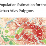
by administrator | Jul 30, 2014 | News
Population estimation for the urban atlas polygons: combining population data (grid, neighbourhood or municipality) with urban land use data; now described in a JRC technical report. More info: qms_h08_intesa_deliverable_2_2_eur_26437.Read article
by administrator | Jul 30, 2014 | News
The UK Office for National Statistics has a geoportal available for statistical geographies. For more info please visit the open geographic data here. – https://geoportal.statistics.gov.uk/geoportal/catalog/main/home.pageRead article