by administrator | Jul 30, 2014 | News
A team of researchers led by the University of Southampton has launched an online project to map detailed population information from countries around the world. The WorldPop website aims to provide open access to global demographic data which can be used to...Read article
by administrator | Jul 30, 2014 | News
Geospatial and statistical data used to support European regional and urban policy needs featured on UN GGIM as Best Practice. More info can be obtained: http://ggim.un.org/ . Presentation by Hugo Poelman is...Read article
by administrator | Jul 30, 2014 | News
The U.S Census Bureau has added to and updated the online collection of subnational population data linked to maps (shapefiles) that are available at the Spatial Data Repository. The Repository contains a variety of data and maps primarily for countries that receive...Read article
by administrator | Jul 30, 2014 | News
Free geographic data from the UK Office for National Statistics is now available. Geographic products, including link between postcodes and NUTS data is now freely available via the INSPIRE compliant ONS Geography...Read article
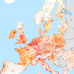
by administrator | Jul 21, 2014 | News
The poster of the GEOSTAT 2011 dataset is downloadable from here: GEOSTAT2011-Poster.Read article
by administrator | Jun 30, 2014 | News
Romanian data can be downloaded from here.Read article
by administrator | Jun 2, 2014 | News
The data are produced based on the results of the 2011 Population and Housing Census and the building data from the Estonian National Topographic Database. Data are available in the statistics mapping application: https://estat.stat.ee/StatistikaKaart/VKR A...Read article
by administrator | Mar 18, 2014 | News
Eurostat GISCO joint WG meeting for National Mapping Agencies and National Statistical Institutes takes place in Luxemburg 18.03-19.03.2014Read article
by administrator | Mar 9, 2014 | News
Statistics Estonia launched an Internet-based map application, which enables to create thematic maps and perform spatial queries based on the results of the 2011 Population and Housing Census (PHC). The statistics map application is for all those interested in...Read article