by administrator | Aug 24, 2014 | News
New York: On August 7, 2014, the European Regional Committee of the United Nations Global Geospatial Information Management (UN-GGIM: Europe) was created. This significant action is the third and final stage in a formation process that began in November 2012....Read article
by administrator | Aug 12, 2014 | News
General guidelines for submitting abstracts: The official language of the conference is English; all abstracts should be written in English. The deadline for submitting abstracts is 1 September 2014. Authors are requested to use the official conference template...Read article
by administrator | Jul 30, 2014 | News
European Conference on Quality in Official Statistics (Q2014) with the special session on “Enhancing relevance of official statistics by georeferencing” will be held at the “Schönbrunn Palace Conference Centre” in Vienna, Austria on 3-5...Read article
by administrator | Jul 30, 2014 | News
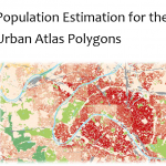
Population estimation for the urban atlas polygons: combining population data (grid, neighbourhood or municipality) with urban land use data; now described in a JRC technical report. More info: qms_h08_intesa_deliverable_2_2_eur_26437.Read article
by administrator | Jul 30, 2014 | News
The UK Office for National Statistics has a geoportal available for statistical geographies. For more info please visit the open geographic data here. – https://geoportal.statistics.gov.uk/geoportal/catalog/main/home.pageRead article
by administrator | Jul 30, 2014 | News
A team of researchers led by the University of Southampton has launched an online project to map detailed population information from countries around the world. The WorldPop website aims to provide open access to global demographic data which can be used to...Read article
by administrator | Jul 30, 2014 | News
Geospatial and statistical data used to support European regional and urban policy needs featured on UN GGIM as Best Practice. More info can be obtained: http://ggim.un.org/ . Presentation by Hugo Poelman is...Read article
by administrator | Jul 30, 2014 | News
The U.S Census Bureau has added to and updated the online collection of subnational population data linked to maps (shapefiles) that are available at the Spatial Data Repository. The Repository contains a variety of data and maps primarily for countries that receive...Read article
by administrator | Jul 30, 2014 | News
Free geographic data from the UK Office for National Statistics is now available. Geographic products, including link between postcodes and NUTS data is now freely available via the INSPIRE compliant ONS Geography...Read article
by administrator | Jul 21, 2014 | News
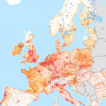
The poster of the GEOSTAT 2011 dataset is downloadable from here: GEOSTAT2011-Poster.Read article