


EFGS 2026 Conference
Geo-enabling the future
30 September – 2 October 2026
Brussels, Belgium
![]()
More information here
GSGF Europe: GEOSTAT Information Service

Lars H. Backer Prize
Statistical Atlas
by EUROSTAT

Latest News
Results from the 2015 GEOSTAT 2 survey on geocoding practices in European NSIs
On behalf of the GEOSTAT 2 project team and the European Forum for Geography & Statistics (EFGS) we would like to express our sincerest gratitude to those of you who kindly contributed to the GEOSTAT 2 survey. The finall version of of survey results is already...
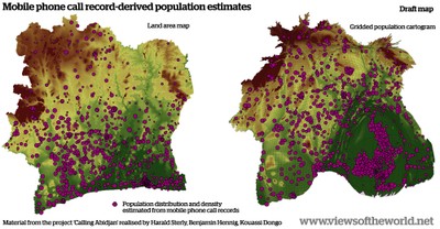
Ivory Coast mobile phone population cartogram
A blog post on population mapping using anonymised mobile phone data from individual call records by Orange in the country of Côte d’Ivoire (Ivory Coast). See blog post for more information.

Statistics Finland making use of open source web-mapping software
Latest Positio magazine introduces Oskari. Oskari is an open source web-mapping software project started by the National Land Survey of Finland. Oskari is now developed by a growing community of developers from governmental organizations as well as from private...
EFGS2015 – European Forum for Geography and Statistics 2015 Conference Vienna, Austria, 10 – 12 November 2015
The European Forum for Geography and Statistics (EFGS) held the 8th Conference on the integration of geography and statistics from 10-12 November 2015 in Vienna, Austria. This conference was hosted by Statistics Austria with the support from Eurostat and in...

NFGS 2015 Conference program and presentations
All submitted presentations data and documents from NFGS Conference (Stockholm, Sweden) you can find here.
Using grid data in order to relate Traffic-Related Air Pollution and Dementia Incidence in Northern Sweden.
Interesting way of using 50 x 50 m grid for study of exposure to ambient air pollution. "Exposure to ambient air pollution is suspected to cause cognitive effects, but a prospective cohort is needed to study exposure to air pollution at the home address and the...